 View toward Pagosa Springs from near base of climb
 Views between Pagosa Springs and base of climb
 Start of climb out of South Fork
 Mid-mountain view of climb out of South Fork
 Mid-climb on Pagosa Springs side.
 Nearing summit on Pagosa Springs side.
  Near ski area below summit on South Fork side.
  Roads approaching pass.
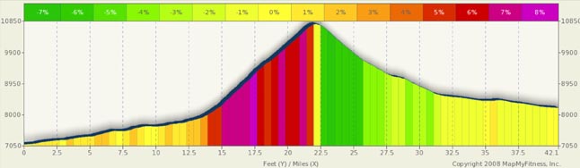
Wolf Creek Pass Summary
If you are heading off into SW Colorado, at some point, you are going to run into Wolf Creek Pass, and this is a good thing. This is a fun and scenic pass. The Pagosa Springs side is a much harder climb than the South Fork side, but, you won’t go wrong with either. If you are looking only at scenery, in my opinion, the scenery between the summit and Pagosa Springs is much better than that on the South Fork side. The Pagosa side is lush and forested, while the South Fork side in more desert like and arid. Both sides are great, it just depends on what you like
The first 14 miles out of Pagosa Springs follow a scenic valley complete with lakes and horse pastures. You are slowly climbing in the 1% to 3% range and by the time you reach the base of the granite roadblock in front of you, you’ll have climbed a good 800 feet. This is not a lung busting climb, instead, it’s a great warm-up for what is to come. As you head toward the pass, you really develop an impending sense of foreboding. As you head north, all you see is this massive rock face in front of you with no apparent way around it or over it. By mile 14 you are starting to feel the forces of nature turn against you, and the transition from 2% to 7%+ is all too quick and you start piling on the elevation gains. The hardest part of this side is at the base. Before you is a double switchback and a climb exceeding 8%. The view to the south is spectacular… but don’t stop on the road to look… too much traffic. There is a scenic overlook off the edge of the road that you’ll want to stop at for the view. After the switchbacks, then grade moderates to a steady 6% to 7 %. It’s unrelenting and there are precious few points that back off or level out. Around mid-mountain you get your one small break as the grade backs down into the 5.5% range. It’s strange how 5% feels like a slice of heaven after a prolonged stint at 7%+. For the majority of this climb, the mountain face is to your left and a deep valley falls away at your right. While this is a heavily forested side, you are generally in the sun, so be careful not to get sun burned.
For those of you descending the Pagosa Springs side, here’s a real chance for some speed. The only major curves are at the bottom switchbacks. So, until that point, you can let yourself go. As always, watch for traffic trying to occupy the same place at the same time as you. Since the repaving projects are done, you have a long smooth downhill with wide roads.
The north side climb is again a relentless climb from South Fork. However, the grades only (“only” he says) top out just over 7% (and that’s near the top) and are generally in the 5% to 6% range. As many passes are in Colorado, the road is carved into the side of the mountain. The face of the hill, going up, is to your right, and a deep valley is to your left. It kind of just leaves you hanging in the air, attached to the side of a mountain. If you want to have great views of the valley, use the turn-outs on the left as rest stops. However, be careful when crossing the traffic lanes. Be sure to look behind you before you move over or you may end up a hood ornament on a Mack truck.
Another interesting feature of this climb is a snow shed, a 900 foot long tunnel. This is avalanche country and the state built, for lack of a better term, a snow chute over a portion of the highway. It’s a fun diversion to the climb and place to take pause on a downhill. Speaking of downhills, the downhill on the South Fork side is fun and wide open. Curves are fairly few and the road is in pretty good shape. However, be very careful as you approach South Fork as you are likely to still have lots of speed, but the road narrows and traffic congestion increases.
H2 level heading
Pagosa Springs is a one pass town, so passes out of the area are limited to Wolf Creek. Durango is to the west over Yellow Jacket Pass (which is not a destination pass... It's a bump in the ground after an easy two mile climb). The route is filled with rollers and is high traffic and high smog. Bike tours like this route as it gets you from Durango the Pagosa Springs fairly easily. There is an alternate E-W route that goes a bit south, along Rt 172 and Rt 151, but there are no passes there. It's actually a very scenic route and low traffic, but adds some 30 miles to the trip. New Mexico is to the south and you’ll find a beautiful rolling route (Rt 84) toward Charma, NM (Bicycle Tour of CO will use this route in 2010). The route is wide open, scenic, and is hot in the summer.
Instead of riding different routes, you may want to take a day off and visit one of the several hot spring pools in town. You can’t go wrong with a nice long soak and swim. Water temps are up to almost 110 in some pools and are a more refreshing 90 in others. Relax.